EERL’s latest research highlighted in CBC News, using laser LiDAR technology from Bridger Photonics Inc. mounted on a plane that flew over oil and gas sites in British Columbia in 2019, confirms methane emissions are much higher than current federal estimates and, for the first time, points to specific reasons why.
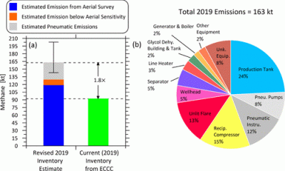
Baseline methane inventory estimates and source categories for the upstream oil and gas sector in British Columbia, Canada. (a) Comparison of new measurement- and on-site pneumatic device count-based overall methane emissions estimated for 2019 with the most current National Inventory estimate for the BC upstream oil and gas sector. (b) Updated breakdown of methane contributions from specific source types in the revised inventory.
Levering airborne LiDAR measurements, parallel controlled releases, and on-site optical gas imaging (OGI) survey and pneumatic device count data from 1 year prior, EERL was able to derive a new measurement-based methane inventory for oil and gas facilities in British Columbia, Canada. More importantly, analysis of high-resolution geo-located aerial imagery, facility schematics, and equipment counts allowed attribution to major source types revealing key drivers of the observed higher emissions. More than half of emissions were attributed to three main sources: tanks (24%), reciprocating compressors (15%), and unlit flares (13%). These are the sources driving upstream oil and gas methane emissions, and specifically, where emerging regulations must focus to achieve meaningful reductions. Pneumatics accounted for 20%, but this contribution is lower than recent Canadian and U.S. inventory estimates, possibly reflecting a growing shift toward more low- and zero-emitting devices.