Addressing Health Inequities and Enhancing Population Health Management Strategies Through GeoAnalytics
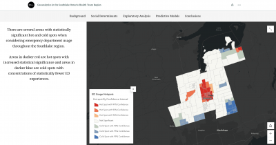
The link between communities, places, and health is well established in the scientific and public health literature, and differences in the characteristics of places can help explain differences in health inequalities. Place-based analysis, as illustrated in this project, offers a lens to better understand the health needs of local communities, evaluate gaps in health service accessibility, and show where opportunities to intervene exist.
The Ontario health system has become more locally oriented with the introduction of Ontario Health Teams, providing a vital link between health policy makers, health service providers, and local communities. OHTs are sources of expertise in data collection, analysis, and evidence-based approaches to improve population health and health equity. As such, there is tremendous potential for these organizations to conduct analyses that are relevant and impactful for local health services and health outcomes.
This project reviewed the potential role of geoanalytics for Ontario Health Teams via an examination of place-based analytic approaches at the local level, examination of use-case scenarios for emergency department visits and mammography screening, and an evaluation of the potential for geoanalytics within a population health framework.
Importantly, we are concerned here with how the analytic results can be used in health system planning and point-of-care, with the goal of improving the health of local populations. For this project, use-cases have been selected to make use of existing data available to Southlake Community OHT and for those that can lead to impactful interventions and upstream engagement strategies in the short-term.
The final evaluation further discusses the potential for spread and scale of the analytic frameworks, data systems, and tools at the Provincial level. Looking towards future digital infrastructure, a geoanalytics approach has strong potential to integrate with existing health data systems and provide a much-needed link between often-inaccessible health administrative data and locally relevant population statistics.
Loading…
No
file
posts are available.
GeoAnalytics Project Evaluation
ArcGIS StoryMap
Geoanalytics in the Southlake Ontario Health Team Region – this StoryMap presents the geoanalytic results for the emergency department and mammography screening use-case scenarios. This StoryMap was created as part of the Rural R:ISK project funded by the Social Sciences and Humanities Research Councile (SSHRC).
Health geoanalytics can support public health organizations such as OHTs in making informed decisions, optimizing resource allocation, and improving the efficiency of their operations. This may lead to cost savings by reducing waste, targeting interventions effectively, and improving overall health outcomes in the population.
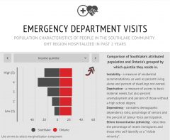
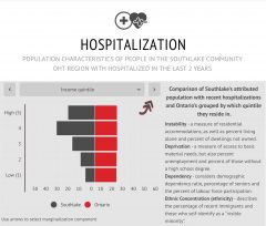
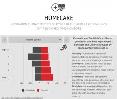
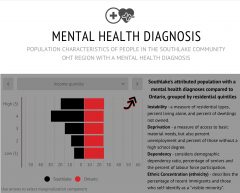
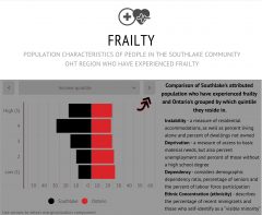
Infographics of Health Indicators for Southlake Community OHT