On October 20th to 22nd, 2010, a field party under my direction tested soil for art debris beneath
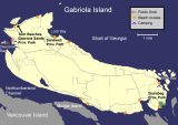
the Thunderbird petroglyph at the Brickyard Hill site and the Sea Wolf petroglyph at the Stokes site on Gabriola Island’s south-central shore. Both sites are above False Narrows and opposite Mudge and Vancouver Islands (Fig. 1). Brickyard Hill is near the Narrows’ northwest end; Stokes near its southeast end. Both are roughly midway in elevation between the huge DgRw-4 shore midden and the DgRw-199 Bluffs burials. Their exact locations are omitted for protection.
2010 Study Areas
Laboratory Tests Prior to Fieldwork
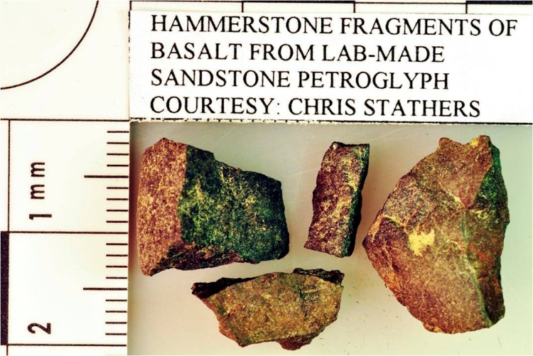
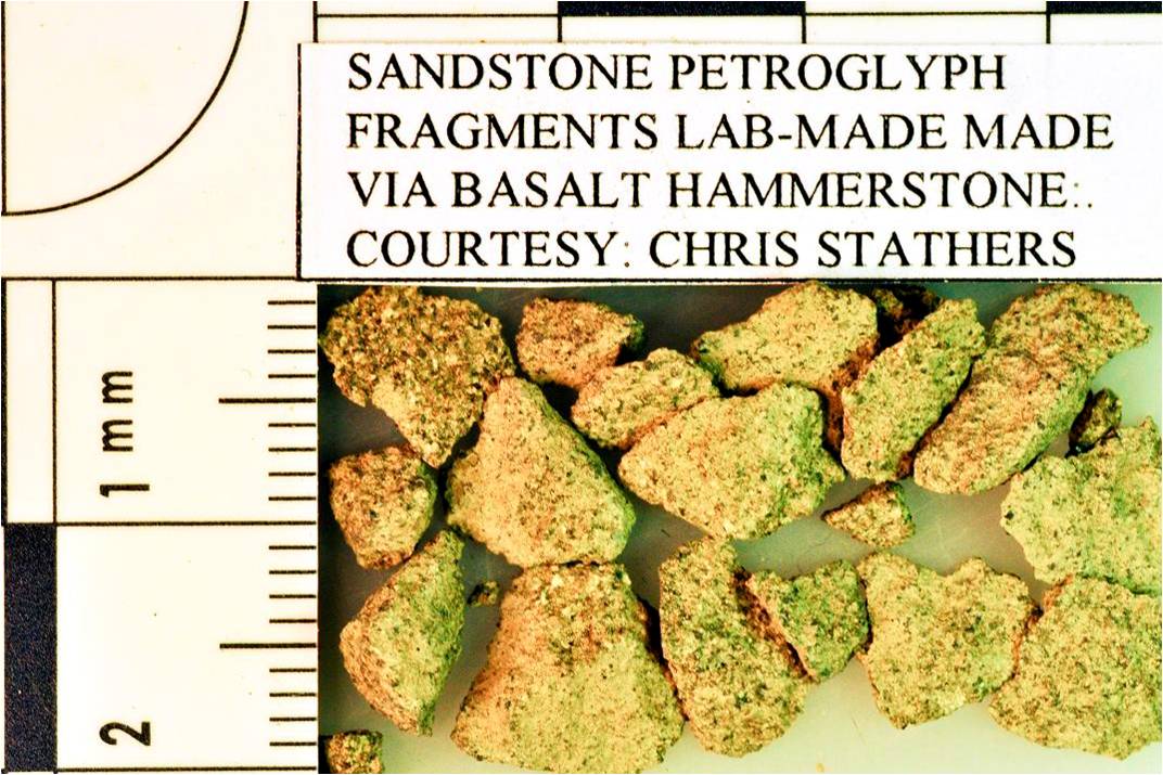
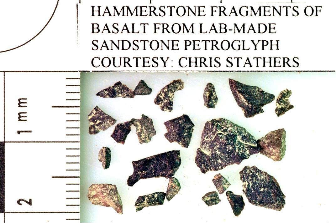
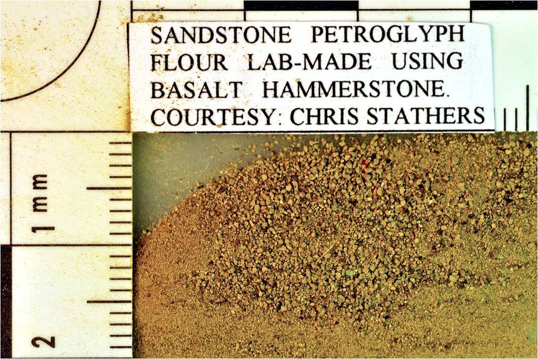
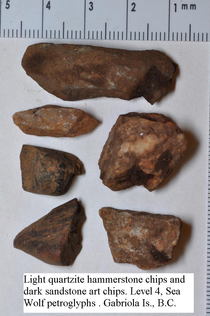
Before fieldwork, we obtained debris from artificially-made sandstone slab petroglyphs resting on a concrete floor, courtesy of Christine Stathers. We found that a common kitchen fry basket (4 mm mesh) captured her few large hammerstone chips (Fig. 2) and sandstone petroglyph chunks (Fig. 3), while a common kitchen sieve (1 mm) retained small hammerstone chips (Fig. 4). The remaining sandstone ‘flour’ smashed by her hammerstone passed through into a tray (Fig. 5). Microscopy shows it to be grey from size reduction, even when coming from dark sandstone. Further work on degree of sphericity may reveal its particles to be flatter and more jagged than worn rounded sand grains that might accompany it in field samples. Before testing we decided on 12 rather than our usual 5 mm for pictograph pigment particles because grinding tools and hammerstones or their chips usually exceed 5 mm.
Testing the Thunderbird Petroglyph
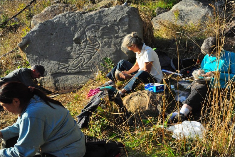
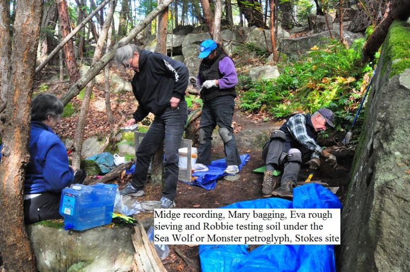
We photographed the ground under the Thunderbird sandstone petroglyph as a guide for later restoration, followed by probing a flat 12 by 25 cm surface to a soil depth of 25 cm needed for our test. This test along the boulder’s base avoided slope wash soil disturbance immediately right. I found that one person scraping can keep three people busy sieving (Fig. 6), while I kept notes and assisted where needed. After removing 5-10 cm of disturbed surface debris and humus for later backfill, we scraped the first 12 mm level into a dustpan using one pull of a rectangular trowel with its blade perpendicular to the level. This ensured an even thickness and cut without mixing that occurs with multiple pulls. Its contents were transferred to the fry basket nested within the kitchen sieve above a tray. We found hammerstones (Fig. 7) and their chips (Fig. 8), line grinders, plus weathered chunks from the boulder in most levels down to 26 at a depth of ca. 31 cm. No artifacts occurred in levels 26 to 31.After manually removing hammerstone chips and discarding pebbles, sieve-clogging silt and clay were suspended by lowering the sieve in a water-filled bucket. Decanting 6-8 times precipitated fine sand and flour of like colour and density (silica). These were bagged and microscopically analyzed in the lab.
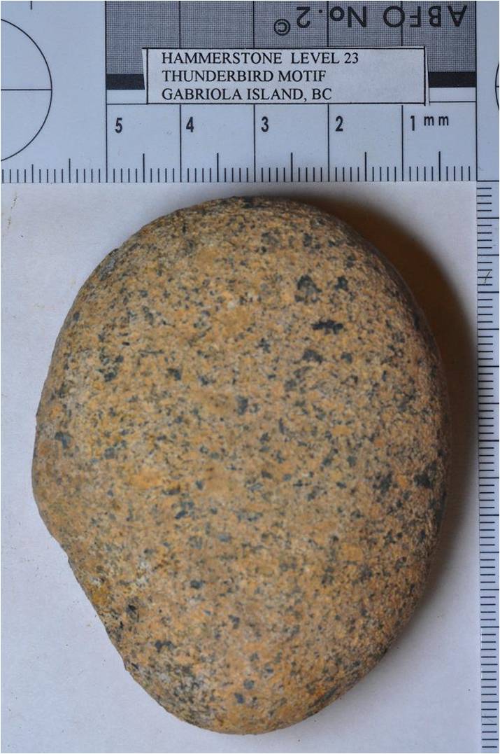

We found sandstone chunks and sandstone, basalt and quartzite hammerstones or their chips in most levels to 26, with rock flour to 31 (see Fig.9 – Thunderbird soil contents Table). Sandstone grinders were in four levels, their flour in 14 levels. Hammerstones and their chips were quartzite (8), quartz (5-6) and basalt (>8), while line grinders were quartzite (7), basalt (6) and sandstone (2). Pebbles were of quartz, cryptocrystallite, conglomerate and basalt, while all rock art chunks were naturally of sandstone. Carbon samples in selected levels will be dated this year.
As lower levels did not require suspension and decantation, we transferred art tool chips in the basket or screen to Zip-Lok bags and used tweezers to transfer carbon samples to aluminum foil. Stones, rootlets and other debris were set aside for backfilling. Pocking was absent on the motif, so grinders were likely used to join their marks into lines. Their absence of stria suggests loose sand was not used as an intermediate abrasive, as in Stathers’ samples. Level 10 at a depth of 12 cm yielded two connecting ochre-coloured dowels, each 12 mm long, plus broken pebbles that may have been used as line grinders. Level 20 at a depth of 25 cm was fine brown loam that was pushed through the sieve. Sieving is the slowest part of testing, so the scraping person can help those who sieve, with any extra crew assisting in sieving.
We finished the petroglyph soil on rock in level 29 at 50 cm. We backfilled with debris that passed our filters. Using pre- and post-test photographs, we placed natural vegetative debris on the ground surfaces in the way we found them, also removing any footprints. While scraping, a crew member found a 4 cm black obsidian dart point in surface debris behind the petroglyph (Fig. 10). It was made 6000-4500 years ago, long before the art and brought from the mid-Fraser Thompson River drainage. It resembles Lehman phase darts, while its obsidian may have come from nearby Garibaldi, Anaheim Lake, Kincome Glacier or distant Mt. Edziza near Telegraph Creek far to the north. A petroglyph 50 m away may have line grinders and hammerstones on its soil but we did not investigate further.

Testing the Sea Wolf Petroglyph
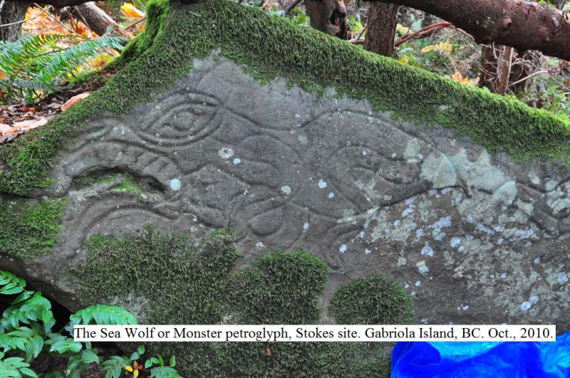
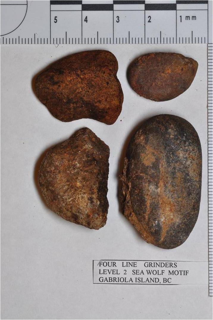
Our second petroglyph was the familiar Sea Wolf motif in the Stokes site several km away (Fig. 11), which we also probed for adequate depth and to avoid subsurface rocks (Fig. 12). It is stylistically similar but on a steeper slope below the Bluffs burials. Just uphill the path narrows due to a 75 cm diameter logging stump which half-covers a small motif. A fresh cross-section of its rings should give a minimum age to the art. A comparative probing of its soil with that of Sea Wolf showed both were satisfactory for testing. I chose Sea Wolf 30 meters downhill because I did not want to remove the stump and disturb the trail. We removed surface debris below the Sea Wolf in a 30 by 40 cm area along its boulder base and 30 cm downhill from a line vertically below the head of the Sea Wolf (Fig. 13). Again we did this to limit slope wash and the effects of buried rock. In its 21 levels above large stones and sterile soil, we found much more organic and rock art debris than Thunderbird. Quartzite, basalt, conglomerate and sandstone hammerstones or their chips were found in nine levels (Fig. 14). Sandstone and several quartzite line grinders were in six levels (Slide 15). Rock flour was in levels 10, 11, 14, 15 and 18 to 21, the last with its grinder. Hammerstones and their chips were quartzite (4), greywacke (2), conglomerate (1), basalt (1), rhyolite (1) and sandstone (1). Line grinders were quartzite (4), sandstone (4), greywacke (2) and rhyolite (1) (Fig. 16 – Sea Wolf soil contents). Its motif was likely made over the same time period as Thunderbird, with selected carbon samples to be dated this year.
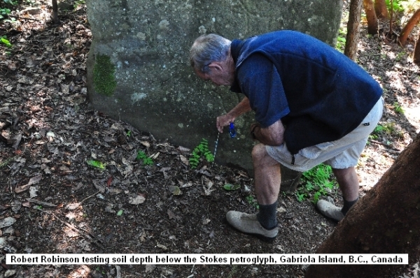
We found a possible pebble hammerstone and many broken round-edged pebbles that fit grooves in the art (photo of line grinders) and may have been used as grinders. Level continued to 21 at a depth of 36 cm where we reached sterile soil. We backfilled the test, scattering leaf litter over its surface as we found it, and photographed it.
Dating the Thunderbird and Sea Wolf Petroglyphs
Until carbon dating is attempted we can only speculate the age of both petroglyphs stylistically and their location near dated archaeological sites. Both are roughly midway in elevation between the huge DgRw-4 shore midden and the DgRw-199 Bluffs burials. Bones in the latter’s Main Burial Cave account for 11 individuals, 6 more in its Fissure and Crevice loci, and 20 more found in 1989. Our Museum’s Radiocarbon Database lists 9 normalized human bone collagen dates. Feature 1, Main Burial Cave, level 3, dated 1400±40 (Beta-90639), 2520±75 at 0-25 cm depth (SFU-546), 3240±50 in level 4 (Beta-74076) and 2760±60 (TO-1145), while its Fissure dated 2270±75 (SFU-610). Crevice Feature 9 dated 2780±75 (SFU-581) and 2830±60 (Beta-37845). More human bone collagen dates from neighbouring DgRw-204 in 3 of 6 burials are 2300±70 (Feature 6; Beta-37846), 2320±70 (Feature 1; Beta-37844) and 2450±60 (Feature 2; Beta-37843) years ago. In the DgRw-4 midden, whale bone collagen with associated artifacts and linked to Burial 52 dated 1640±50 years ago (TO-1396). Charcoal at 136-144 cm depth in dark brown beach sand and gravel dated 1670±90 years ago (GaK-2754). Both midden dates are similar and Marpole phase, while most Bluffs dates are Locarno phase. The midden also has several ground slate fragments that may be Locarno like those in the Bluffs burials. A fragmented antler carving in the midden has the same curvilinear style as the Sea Wolf and Thunderbird petroglyphs.
Midden and Bluffs dates and artifacts suggest continuity from Locarno through Marpole to Coast Salish and do not support the early Northwest Coast’s “discontinuity” model initiated by Harlan Smith, Hill-Tout and Boaz a century ago, and later supported by Borden. Burley and Beatty (1987:199-207) still support archaeological and skeletal change in the Gulf of Georgia from what they see as recent emigration of Coast Salish from an unknown inland area. “Continuity” theorists suggest the regional archaeology need not include emigration. Gordon’s (1974: ii) early research supported the continuity model even before archaeological research was complete on the DgRw-4 midden. Genetically-based discrete traits in her 84 burials suggested Marpole evolved into Developed Salish people. Both also had similar eating habits, as seen in tooth wear.
Gordon’s midden burials were later compared with the Bluffs’ Locarno phase burials, Curtin (1999, 2002) adding continuity from early Locarno to Marpole based on discrete traits, teeth and post-craniometrics. But cultural differences exist in their burials. Gordon’s were intact, cranially deformed and unburned flexed burials in a shell midden. Curtin’s were burnt, undeformed and scattered amidst fish bone in caves and crevices well away from the sea. While their differences need not invoke emigration because cranial deformation appeared throughout the Northwest Coast about 1000 AD, they do appear strangely separate. Reasons for deformation are unknown but may relate to the rise of a class hierarchy based on population growth via a change from sea mammal hunting to salmon fishing and winter storage. People became more dependent on salmon and distant trade. Gordon says deformation was done by binding babies in newly introduced cradle boards. Regarding trade, the atlatl point in surface debris suggests Marpole trade with the mid-Fraser Thompson River drainage. Roy Carlson (pers. comm. Nov., 2010) says it resembles Lehman phase points dating 6000-4500 BP (Rousseau 2008 Fig. 8).
In conclusion, the Thunderbird and Sea Wolf petroglyphs were likely made in stages, their highly visible ground motifs likely returned to again and again for deepening with line grinders. Dating panel growth stages may lead to accepting that most rock art was done or reapplied over periods of time. It may also help us to fully comprehend the true length of artistic traditions. Two issues remain that demand satisfaction. Will this method work in soils with naturally-occurring sharp chips that might resemble hammerstone chips? While possible, hammerstones are chosen because they are harder than the rock where the art is made. This rock is usually the same material as the soil chips through natural weathering. Furthermore, these chips should occur in all or most levels, while hammerstone chips occur only in those levels when the art was made. The second issue concerns the differentiation of rock flour from eroded sand or other soil grains. Rock flour from ground petroglyphs is prolific and should differ from very fine sand or flour naturally present in the soil or from weathering of the art rock.
References
Curtin, Joanne A. 1999 Biological relationships at the Locarno/Marpole transition: The evidence from Gabriola Island. The Midden Vol. 21, No. 2, pp. 3-4.
2002. Prehistoric mortuary variability on Gabriola Island, BC. Simon Fraser University, Burnaby.
Gordon, Marjory E. 1974. A qualitative analysis of human skeletal remains from DgRw-4, Gabriola Island, British Columbia. Unpub. MA thesis, University of Calgary, Dept. of Archaeology.
Matson, R.G. 2010. The Place of the Locarno Beach culture in the Development of the Ethnographic Northwest Coast Cultures. Chapter XII In http://www.anth.ubc.ca/fileadmin/user_upload/anso/LOA_PDFs/Matson_Crescent_Beach/ChapXII.pdf
Rousseau, M. R. 2008 Chipped Stone Bifaces as Cultural, Behavioural, and Temporal Indices on the Central Canadian Plateau. Pp. 221-250 in Projectile Point Sequences in Northwestern North America, R. Carlson and M. Magne, eds. Archaeology Press, Simon Fraser University, Burnaby.
Acknowledgements
Mary Wohlleben, Eva Linklater, Midge Gordon and Robbie Robinson assisted in testing the Gabriola petroglyphs. Both pairs of landowners Glenna Borsuk & Don Gatley and Dave & Keni Lorette provided access to the art, and Don and Mary covered three Stokes petroglyph boulders a week before our arrival to keep their soil dry for sieving. At the Museum, Don Gribble, Alicia Ghadban and Frank Bayerl separated samples using sieving, flotation and microscopy. Frank proofread this paper.