European trade goods mark Chipewyan emergence from the prehistoric Late phase (1300-200 years ago) of the Taltheilei tradition. Contemporary with Chipewyan are Caribou Inuit descendents of a coastal Thule tradition that entered the north Beverly range. Their tools are not prehistoric, but are included here because they ended the long tradition of herd following by preventing the Chipewyan from pursuing the caribou north in summer.
Historic Chipewyan
European goods were carried inland by the Cree and Chipewyan well in advance of Hudson Bay Company personnel. Traded for fur and meat, these iron, steel, brass, copper, cloth, pottery and glass items are found among the collapsed poles of tent rings and mixed with quartzite tools in top archaeological levels. Too recent for radiocarbon-dating, they and their users are described by Hearne (1795) who visited forest and tundra, and Mackenzie (1801) who crossed the forest. Absent stratigraphically but recorded historically are perishable crude wood paintings, quillwork, moosehair embroidery, double paddles borrowed from the Caribou Inuit and birchbark boiling baskets from the Cree (Gordon 1977:73).
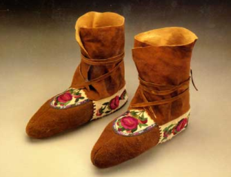
Slavey Mocassins © Bata Shoe Museum, Toronto
Above: Slavey smoked moose and caribou hide, ankle-wrap mocassins are decorated with floral stitch, horsehair piping and porcupine quill applique. The Slavey are neighbours of the Chipewyan to the west.
Chipewyan on the Tundra
When ethnologist Ernest Burch (1972:340) studied the Caribou Inuit, the Chipewyan had deserted the tundra for almost two centuries, but historic accounts (Smith 1970:315) and archaeological data provide evidence of their earlier presence. On February 24, 1772, Hearne (Glover ed., p.176) encountered a Caribou-Eater family that had followed the caribou south from their Warden’s Grove tundra camp on the Thelon River. Hearne also found Chipewyan at Lake Dubawnt on his first Coppermine attempt in 1769 A.D., just as we found their tundra tools there and at Sid, Mary and Mosquito Lakes in the 1970’s. Two years later, he and Chipewyan familar with the tundra passed the Artillery Lake sites. on their way to Bloody Falls on the Coppermine River.
Chipewyan Tools and the Treeline
Tundra sites are larger but fewer than forest sites, confirming Hearne’s observations that large groups assembled to hunt caribou at water-crossings. The smaller number of tundra sites suggest lessened emphasis as the fur trade drew the Chipewyan south. In fact, most tundra sites are near treeline in the Sid-Mary-Mosquito Lakes cluster, with other tundra sites north or west at Artillery and Clinton-Colden Lakes, the Thelon River from Warden’s Grove to Beverly Lake, and Grant Lake. One large forest cluster is at Damant, Rennie, Knowles and Firedrake Lakes, an area still used sporadically by Chipewyan who fly in from Black Lake and Stoney Rapids in northern Saskatchewan. Others are at Whitefish and Lynx Lakes, Noman-Nonacho and Gray Lakes, Athabasca, Cree and Black Lakes, with scattered sites at south Artillery Lakes and along the upper Churchill River. Until the discovery of the tundra camps it was assumed that Chipewyan forest hunters gathered at treeline to intercept the southward-bound caribou (Smith 1978:84). The large number of treeline sites reveal hunter movement south from summer tundra to winter forest. Few appear as late winter camps because hunters cannot sustain the pace of pregnant cows moving north through deep snow nor accept the risk of crossing rivers covered with dangerous candle ice. My data suggest hunting families began to follow the herd in late May and June after lakes were clear of ice. Of 203 sites, 156 are in forest and 47 on tundra.
Mixed with bone and wood in some tundra and many treeline and forest sites are metal and plastic trade goods. Forest trade items of brass, copper, steel and glass predominate because they are closer to fur trade routes. KjNb artifacts are from Warden’s grove tundra; KeNi and KcNg artifacts are from forest camps at Whitefish and Lynx Lakes.
Conclusions Regarding Site Distribution and Artifacts
As the forest was affected earliest and heaviest by fur trade and church influences, it had a higher population with a more visible legacy in the form of widely scattered trade copper and iron items, cabins and graves. But of the remaining stone tools it can be seen that forest points, scrapers and flakes have greater retouch, possibly in keeping with difficulties in procuring new replacement stone because it was snow-covered or faraway in tundra quarries.
Historic Caribou Inuit
Lured by the fur trade, the Chipewyan took up year-round residence in the forest. Their abandonment of the tundra left an enormous area uninhabited the whole year, a gap soon filled by Caribou Inuit. The Caribou Inuit had traded their traditional maritime lifestyle to subsist on caribou which, due to its migration, enticed the Inuit farther and farther southwest towards the forest where the Chipewyan dwelled. The Inuit spread from the Beverly Lake calving ground 100 km upriver to the Crossing-Place-of-Deer (Tyrrell 1902, map), but were stopped by those Caribou-Eater not drawn to the fur trade. Accounts exist of mutual Chipewyan and Inuit avoidance after spotting the others’ campfire smoke (Blanchet 1928:8; Smith & Burch 1979:76-101), but other accounts, some fanciful, state both claimed the land and died in the resulting skirmish (Mallet 1930:31-41).
Until their relocation to coastal villages in the 1950’s, the Caribou Inuit were regarded as successful inland hunters. But this was not so because the Chipewyan prevented them from following the caribou to their winter range, ultimately starving them. Herd followers without suitable alternate game cannot adapt if they are not free to roam the whole range. Several theories have been proposed to explain Caribou Inuit origins. The primitiveness of their tools suggested to Birket-Smith (1929) that they had occupied the Barrenlands for centuries. Taylor (1968) and Burch (1978) opt for a northern link with Netsilik Inuit occupying Boothia Peninsula and King William Island. The Netsilik are nomadic seal hunters who use sea ice igloos extensively but their dialect resembles that of the Caribou Inuit. Linnamae & Clark (1976) favour a connection with Hudson Bay coastal Inuit based upon contemporaneous surface dwellings of both groups and their eastern proximity.
I favour Taylor and Burch’s proposal of a northern link using archaeological evidence and historic accounts of Inuit camps. The crossing of Nadlok on the Burnside River just south of the Arctic Circle has Copper Inuit artifacts with coastal affinities (Gordon 1988), but is also on a trade route from Coppermine River placer deposits southeast to Beverly Lake (Stefannson 1919). Nadlok’s abandonment just before the Caribou Inuit occupied Beverly tundra about 1825 A.D. is contemporary with Caribou Inuit copper at Grant Lake. As other deposits are rare or absent, copper was likely carried past Nadlok by Copper Inuit in the process of becoming Caribou Inuit, a process hastened by the distance to the copper source. Although rare with south and eastern spread, Caribou Inuit copper is thinly distributed north of the treeline. When Grant Lake was surveyed by the Tyrrells in 1896, they found Hearne’s Chipewyan had been replaced by Caribou Inuit (Tyrrell 1898, 1902). Several decades after Hearne, Inuit camps were found on the Back River (Back 1836). Except for two tent rings at Thanakoie Narrows near Clinton-Colden Lake (Morrison ms., ASC Archives), sites cluster on the lower Back, Thelon and Dubawnt Rivers. These sites are near Stefannson’s (1919) Akilinik camp at Beverly Lake which traded copper for driftwood for making tent poles, sledges and spears.
| from Gordon 1996. People of Sunlight; People of Starlight: Barrenland Archaeology in the Northwest Territories of Canada. Archaeological Survey of Canada, Mercury Series Paper 154. Canadian Museum of Civilization, pp.27, 29, 51-53 |