“Clyde River’s online atlas puts Inuktitut names on the map” by John Thompson
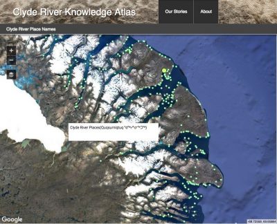
Dr. D. R. Fraser Taylor, Director, Geomatics and Cartographic Research Centre (GCRC), Carleton University, is very pleased to share this article entitled “Clyde River’s online atlas puts Inuktitut names on the map” by John Thompson (in the 5 February 2019 publication of Nunatsiaq News). The atlas was first publicly unveiled during the ArcticNet science conference in Ottawa in December 2018. As is noted,”The project has received training and technical support from Amos Hayes and Robert Oikle of the Carleton University’s Geomatics and Cartographic Research Centre, and from Peter Pulsifer of the Exchange for Local Observations and Knowledge of the Arctic”. The atlas project was funded by Tides Canada and Indigenous and Northern Affairs Canada. https://nunatsiaq.com/stories/article/clyde-rivers-online-atlas-puts-inuktitut-names-on-the-map/
The GCRC is committed to ongoing innovative cybercartographic atlas developmental work with Indigenous communities, grounded in their needs, interests and priorities, consistent with the objectives of the Truth and Reconciliation Commission.