‘Possession’, ‘Ownership’, and Tr’ochëk National Historic Site
By Peter Coffman
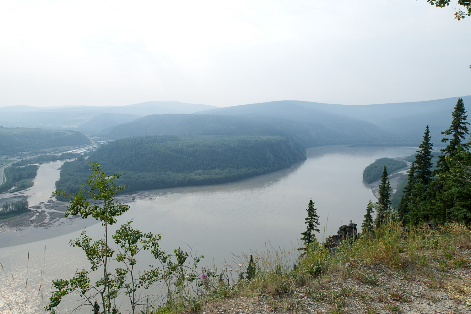
You know the old saying, ‘possession is nine tenths of the law’. Obviously, that’s never been literally true. And even if it had been, it starts to fall apart when we discover that ‘possession’ doesn’t mean the same thing to everyone. The story of Tr’ochëk (pictured above) illustrates this.
The flat, pointy area of green land in the left middle-ground of the photograph above was, for millennia, a seasonal fishing camp called Tr’ochëk, used by the Tr’ondek Hwech’in first nation. It sits just across the mouth of the Klondike River from the site of what is now Dawson City, Yukon. Remote and hard to access from settler cities, it was largely undisturbed well into the nineteenth century.
That all changed in 1896, when copious amounts of gold were discovered in nearby Bonanza Creek. Within a couple of years, tens of thousands of prospectors had come to this place in a desperate lunge for wealth. A cunning entrepreneur named Joseph Ladue realized that staking claims on the only flat land available for settlement was a more stable (and less onerous) route to wealth than scraping stream beds for gold. Thus, Dawson City was founded, just to the left of what’s visible in the photo.
Ladue charged extortionate amounts for his plots, because he could. Frustrated by his terms, prospectors began negotiating with the Tr’ondek Hwech’in people for land across the Klondike River, in their traditional fishing settlement. And here, I think, the ‘gulf of incomprehension’ between the two cultures, which I explored in another blog, made its presence felt again.
The Tr’ondek Hwech’in soon lodged a complaint with the Anglican Bishop, William Carpenter Bompas, who was one of the few people in any sort of authority who would listen to them. The prospectors, they claimed, had bought cabins from them. Now, instead of moving the cabins across the river to Dawson, as was expected, they were leaving them in Tr’ochëk and squatting there. One of the cabins had even been turned into a saloon.
When Bompas put this to the prospectors, they claimed that they had bought the land for an agreed-upon price, and it was theirs to occupy. So, who’s telling the truth?
I confess that, fairly or not, my instinct is not to take the prospectors’ claims at face value. The Gold Rush attracted more than its fair share of hucksters, cheats, and con-men. Stories of them swindling each other are legion.
But it’s very possible that neither side was being entirely disingenuous. The settlers may honestly have believed that they had purchased the cabins and the land, because that’s what their paradigm of property ownership entailed. But to the Tr’ondek Hwech’in, this would have been inconceivable. Cabins were objects – possessions that could be bought and sold. But the land was an entirely different matter; it belonged to no one. To them, you couldn’t own the land any more than you could own the sun, or the air, or the rain. When the two sides reached a deal, their world views would have given them very different understandings of what that deal meant.
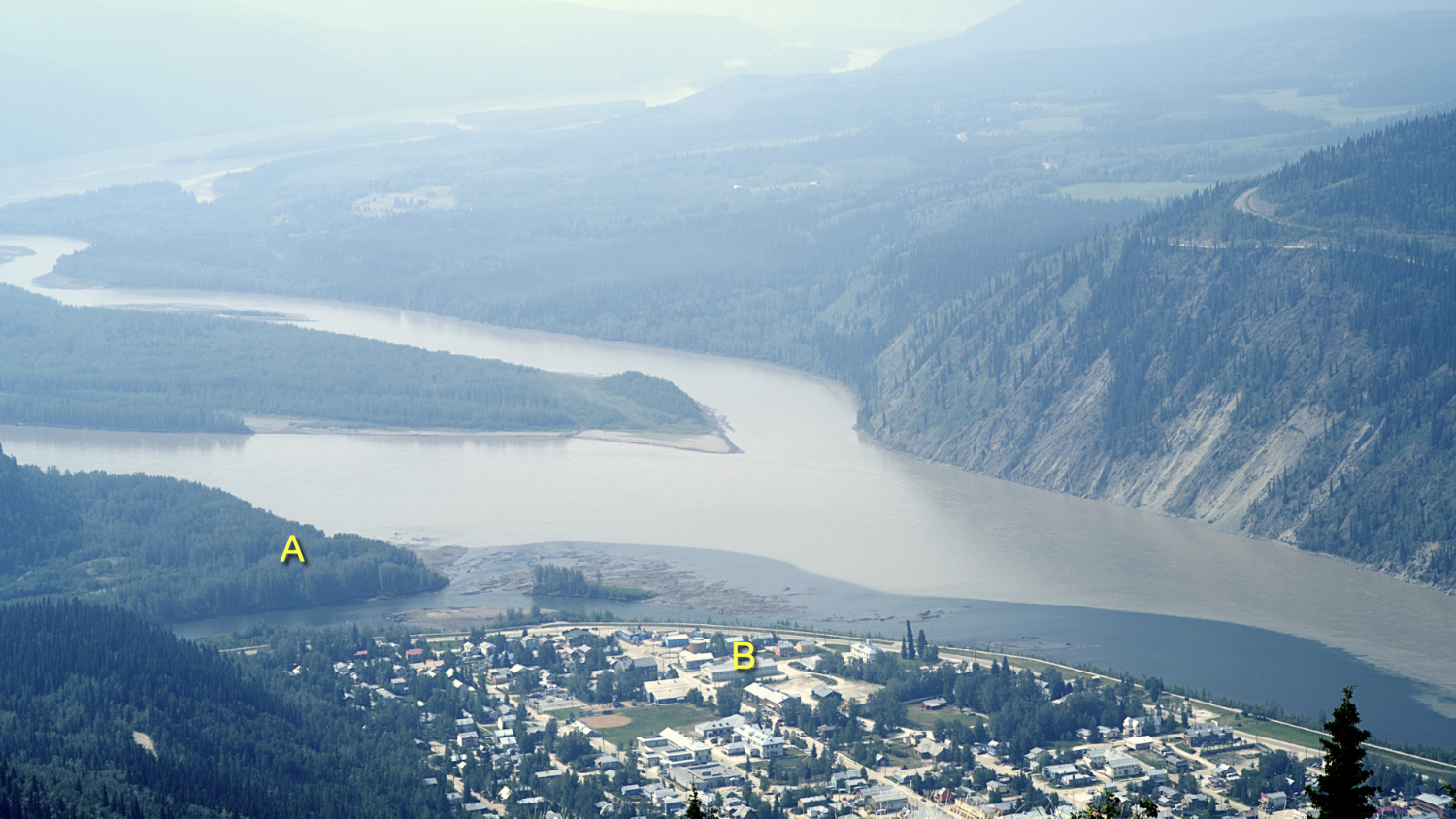
Be that as it may, the miners took possession of the land and the Canadian Government wasn’t inclined to make them give it back. Such was the quality of the prospectors’ stewardship of Tr’ochëk that it soon became known as ‘Lousetown’. In the hope of maintaining a camp close to their traditional (and extremely fruitful) fishing area, the Tr’ondëk Hwëch’in moved across the mouth of the Klondike River, to the southern tip of the area that was fast becoming Dawson City – from “A” to “B” in this photo:
There was just one problem. The government of Canada had already claimed ownership of that land, and planned to use it for their Government Reserve. This would become the ‘enclave of power’ that I discussed in an earlier blog. Once again, the indigenous people found themselves at the mercy of an utterly alien understanding of what occupation and possession of land meant.
To be crystal clear: I’m not telling this story in order to exonerate the settlers. Without a doubt, their cultural blindness was self-serving, based in ignorance, fueled by greed, and founded on an unconscionable belief in their own superiority. But my job as a historian is not to reduce the past to a parade of heroes and villains. It’s to examine places, people and events of the past, and to try to understand why they unfolded as they did. And as an architectural historian, it’s especially to explore how our built environment can unlock those dynamics for us. Because who knows, maybe doing so will help us understand some problems we still grapple with – the ‘gulf of incomprehension’ is, I think, very much still with us.
So what happened next? Long story short: the Tr’ondëk Hwëch’in had to move their fishing camp yet again, this time to a site a few kilometres downstream that came to be known as Moosehide. Today, Moosehide forms part of the Tr’ondëk-Klondike UNESCO World Heritage Site. UNESCO granted that status in recognition of the area as an “exceptionally preserved tangible illustration of dramatic modifications of land use, settlement patterns, and economy caused by the rapid and large scale of the colonising incursion of newcomers into the ancestral land of the Tr’ondëk Hwëch’in in search of gold and precious minerals.”
Tr’ochëk is now a National Historic Site. Archaeological research, along with oral history, are yielding a rich, textured understanding of how the place was used for millennia. It also brings a difficult but important aspect of our history into sharp focus.
During my recent sabbatical, I gathered material from across the country for a new course we’ll be offering on Canadian architecture. I’ll be using this blog to think out loud about some of the places I visited and the issues they raise.
Peter Coffman
peter.coffman@carleton.ca
@TweetsCoffman
@petercoffman.bsky.social
Further Reading:
Helene Dobrowolsky, Hammerstones: A History of the Tr’ondëk Hwëch’in (Dawson City: Tr’ondëk Hwëch’in, 2014)
Parks Canada, Tr’ochëk National Historic Site
UNESCO, Tr’ondëk-Klondike World heritage Site